Mark the plume.File the evidence.
One satellite pass over your site after a dust event, outlined for visible dust and handed back as a marked image and an extent layer.
- GSD
- 0.5–2 m
- Cadence
- per event, on request
- Imagery
- high-resolution satellite
- Spectral
- RGB
- Pass
- date, time UTC
- Center
- lat, lon
- Layer
- plume extent, polygon
- Source
- crusher feed
What you have when the call comes in
A neighbor phones the front office, or the air agency forwards a complaint with a date and a time on it. Dust, they say, from the quarry. You are the environmental manager, so it lands on you.
You start with what the site wrote down. The shift log, the water truck record for that day, the wind reading for that hour, the line in the complaint log. Somebody on the ground saw dust coming off the haul road near the ramp, or thought they did. A technician took a few photos from the pit rim. They show a haze and a truck, and they do not show how far it went or which way, and the crusher is somewhere out of frame.
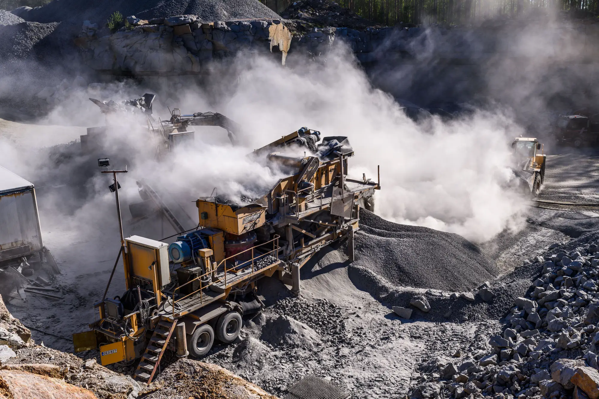
Fig. 1From the ground: the crusher feed and the cloud it throws. Where the far edge of the plume went is out of sight.
The agency's inspector works the same way from the other side of the fence: wind speed and direction noted, visible emissions photographed from the property line, a few lines in a report. Your reply and their findings both rest on what one or two people could see from where they stood.
That is a thin file to defend a suppression budget with. The truck that sprays the haul road gets more hours because the haul road is the familiar answer, and nobody can show whether the plume started at the road, the crusher feed or the stockpile next to it.
This service adds the view from above. You tell us the site and the window, and we outline the visible dust on a satellite pass and send you the marked image and the extent. It sits next to the log entry instead of replacing it.
What comes back for each event
An early-access offer. We are shaping the deliverable with the first sites that ask, so the format below is what we plan to send and may change as we learn.
2.1 / Image
Marked-up plume image
The satellite frame with the visible plume outlined, plus the date and time of the pass and the coordinates, so it reads like an evidence tag. It goes into the complaint file or the dust management plan review as the observation record.
2.2 / Shapefile
Plume extent layer
The outline of the visible plume as a polygon layer, for your GIS and the site plan. Overlay it on the haul road network, the crusher pad and the stockpile footprints to see where the cloud sat and which way it ran.
2.3 / Annotation
Source area context
A note on which source area is visible at the start of the plume: a stretch of haul road, the crusher, a pile. It points at an area in the frame. It does not name a single truck or machine.
2.4 / Per event
One delivery per event
Each delivery ties to the event you named: the site, the date, the window. There is no standing feed. If you have two complaints in a month, that is two requests.
How it works
Step 1: You flag the event
Send the site boundary, or a point and a radius, and the date and window you care about. A complaint reference helps if you have one.
Step 2: We task the next usable pass
The satellite has to be overhead in daylight with a clear view of the site. We tell you what the next usable pass looks like before we commit to it.
Step 3: Visible dust is outlined
Where dust is visible in the frame, the plume is segmented and drawn as an extent. If there is no visible plume on the pass, you get the frame and that answer.
Step 4: You get the image and the layer
The marked image and the extent layer, with the source area noted. They open in GIS and attach to the file.
Where it fits your workflow
Attach the extent layer to the dust management plan review, or to the complaint file you send back to the agency, as an observation record that outlasts a shift log. When you decide where the next water truck or binder application goes, you have a drawing of the plume to point at.
Limits
These are the ways a plume image can mislead you. They are stated up front because a regulator will read the file too.
L1Visible dust only
The outline shows dust you can see from above. It is not a PM10 reading, not a particulate concentration, and not an opacity reading under any method. A fine plume that is faint against pale ground may be only partly outlined.
L2One moment, not a record
The pass is one frame at one time. A plume that rose and died in the hour before the satellite arrived is not in it. This does not show the whole day.
L3Daylight and clear sky
Optical imagery needs light and a clear view. Night, heavy cloud and thick haze defeat it, and the pass we get depends on when a satellite is overhead. We cannot promise it falls on the afternoon of your complaint.
L4Resolution sets the floor
At 0.5–2 m a pixel is a few feet across at best. A wisp behind one truck on a narrow road may be too thin to outline. A larger cloud is easier to outline than a thin one.
L5Area, not machine
The source note points at a road, a crusher or a pile. It does not tell you which truck or loader raised the dust.
L6Not a compliance measurement
This is an imagery-based evidence layer. It is not a certified emissions measurement and does not stand in for the monitoring your permit requires.
Who it's for
- EHS and environmental managers at mines and quarries who need to answer a dust complaint with more than a log entry.
- Teams deciding where suppression spend goes and wanting a picture of where the dust started.
- Regulators and inspectors reviewing a complaint who want a view from above to set beside a ground observation.
Who it's not for
- Sites that want continuous dust monitoring. This is a picture per event, not a feed.
- Teams that need PM10 or any concentration reading. That takes instruments on the ground.
- Teams who need a plume traced to a single machine.
- Sites that need a certified measurement to meet a permit condition.
Questions from EHS and permitting
Does this measure PM10 or air quality?
No. It outlines the visible plume only. It carries no concentration, no opacity and no air-quality number.
Can you image at night or through cloud?
No. It is daylight, cloud-free optical imagery only.
How fast after an event can you get a pass?
It depends on the next usable overpass over your site, and we will say what that looks like when you flag the event. We do not guarantee same-day.
Can it show which machine caused the dust?
Only the source area in frame: a stretch of haul road, the crusher or a pile. Not a single truck or loader.
Is this a certified compliance tool?
No. It is an observation record from imagery. It does not replace the monitoring your permit requires, and we do not claim it would settle a violation.
How do we check it against what our own people saw?
Set the outline beside your shift log, the technician's photos and the wind reading for the time of the pass. Tell us where your ground observations are when you flag the event and we can note them against the image.
Will a regulator accept it?
We cannot answer that for your agency. It is an extra observation to attach to the file and your regulator decides what weight to give it.
Who owns the images and layers?
Terms for use and ownership of what we deliver are written into the agreement before work starts. The satellite operators keep their own licenses on the source imagery.
How is it priced, and how do we start?
Early access is scoped per site and per event. You get a written scope before anything is tasked. We are not publishing a price.
Request access for your site.
Tell us the site and the kind of event you need imaged, or ask in the chat.
Request early access